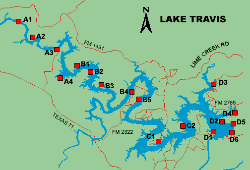
Lake Travis Boat Ramps

B1: Turkey Bend
- On the north side of Lake Travis approximately 9.5 miles west of
Lago Vista. Take FM 1431 to Shaw Drive and continue 1.8 miles to the site
entrance.
- Fee required
- Open all year
- Operated by The Lower Colorado River Authority 1(800) 776-5272 x3366
B2: Muleshoe Bend
- Upper south side of Lake Travis near the Ridge Harbor subdivision,
45 minutes from downtown Austin. Take Texas 71 to Burnet County
Road 404. Turn right and proceed 4.5 miles to CR 414. Turn
right and travel about 1.5 miles, then take another right just before the
entrance to Ridge Harbor. After almost a mile, the pavement will end. Continue
0.3 miles on the gravel road to the entrance.
- Fee required
- Open all year
- Operated by the Lower Colorado River Authority 1(800) 776-5272 x3366
B3: Gloster Bend
- North side of Lake Travis about 6 miles west of
Lago Vista, near the Travis Peak community. Take FM 1431 to Singleton Road
and continue 3.3 miles to the site entrance
- Two-lane concrete ramp
- No fee required
- Park is open all year for day use. Ramp is accessible 24 hours a day.
- Operated by the Lower Colorado River Authority 1(800) 776-5272 x3366
B4: Pace Bend/Collier Cove
- Located in Pace Bend park about 30 miles west of Austin. Take Texas
71 west to RR 2322 (Pace Bend Park Road). Turn right and travel 4.6 miles
to the park entrance. Once inside, follow 2322 to Collier Cove ramp.
- One-lane concrete ramp
- Fee required
- Open all year
- Operated by Travis County Parks (512) 854-7275
B5: Pace Bend/Tatum Cove
- Located in Pace Bend park about 30 miles west of Austin. Take Texas
71 west to RR 2322 (Pace Bend Park Road). Turn right and travel 4.6 miles
to the park entrance. Turn right on Grisman Trail to reach Tatum Cove ramp.
- One-lane concrete ramp
- Fee required
- Open all year
- Operated by Travis County Parks (512) 854-7275
Return to map
C1: Dink Pearson Park
- From US 183, take FM 1431 south 11 miles to Lohmans Ford Road. Turn left
and travel 7 miles to park entrance.
- Unimproved boat ramp
- No fee required
- Open all year from sunrise to sunset
- Operated by Travis County Parks (512) 854-7275
C2: Arkansas Bend
- From US 183, take FM 1431 south 11 miles to Lohmans Ford Road. Turn left
and go 4 1/2 miles to Sylvester Ford Road. Turn left and travel 1 1/2 miles
to the park entrance.
- Two-lane concrete ramp
- Fee required
- Open all year from sunrise to 9 pm
- Operated by Travis County Parks (512) 854-7275
Return to map
D1: Mansfield Dam Park
- From the intersection of RR 620 and FM 2222, travel south 4.9 miles. Turn
right onto Mansfield Dam Road, just south of the dam. The park entrance is
on your left.
- Four-lane concrete ramp at high lake levels and two-lane at low levels,
with an adjoining wheelchair-accessible courtesy dock
- Ramp is usable to an elevation of 622 feet msl
- Fee required
- Operated by Travis County Parks (512) 854-7275
D2: Bob Wentz at Windy Point
- From the intersection of RR 620 and FM 2222, take RR 620 south 1.3 miles
to Comanche Trail. Turn right and travel 3.1 miles to park entrance on left.
- Two-lane concrete ramp for sailboats only
- Fee required
- Day use only
- Operated by Travis County Parks (512) 854-7275
D3: Sandy Creek Park
- From the intersection of RR 620 and FM 2222, take FM 2222 (Bullick Hollow
Road) west 2 1/2 miles to FM 2769. Turn left and travel 4 miles to the town
of Volente. In Volente, turn right onto Lime Creek Road and follow 6 miles
to park entrance on the left.
- Two-lane concrete ramp
- Fee required
- Operated by Travis County Parks (512) 854-7275
D4: Cypress Creek Park
- From the intersection of RR 620 and FM 2222, take FM 2222 (Bullick Hollow
Road) west 2 miles. The park entrance is on your left, just before the intersection
of Bullick Hollow Road and FM 2769 (Old Anderson Mill Road).
- Two-lane concrete ramp
- Fee required
- Open all year from sunrise to 9 pm
- Operated by Travis County Parks (512) 854-7275
D5: Hippie Hollow
- From the intersection of RR 620 and FM 2222, take RR 620 south 1.3 miles
to Comanche Trail. Turn right and travel 2 miles to park entrance on left.
- Two-lane concrete ramp with a maximum parking capacity of 17
- Fee required
- Open all year for day use; hours change by season
- Operated by Travis County Parks (512) 854-7275
D6: Tom Hughes Park
- From the intersection of RR 620 and FM 2222, take RR 620 south 2.3 miles
to Marshall Ford Drive. Turn right on Marshall Ford and travel 0.2 miles
to Park Drive. Turn right and go 2.8 miles to the park entrance.
- Fee required
- Open for day use; hours change by season. Closed Dec 1 -Jan 31.
- Operated by Travis County Parks (512) 854-7275
|
|


